
Ecosystem Management
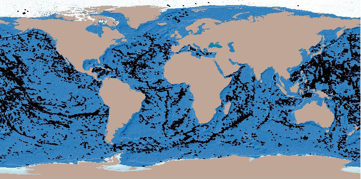
There is a rising concern regarding the accumulation of floating plastic debris in the open ocean. However, the magnitude and the fate of this pollution are still open questions. Using data from the Malaspina 2010 circumnavigation, regional surveys, and previously published reports, we show a worldwide distribution of plastic on the surface of the open ocean, mostly accumulating in the convergence zones of each of the five subtropical gyres with comparable density.
Abstract

Reefs at Risk Revisited brings together data on the world’s coral reefs in a global analysis designed to quantify threats and to map where reefs are at greatest risk of degradation or loss. We incorporated more than 50 data sources into the analysis—including data on bathymetry (ocean depth), land cover, population distribution and growth rate, observations of coral bleaching, and location of human infrastructure.
This dataset shows the global distribution of mangrove forests, derived from earth observation satellite imagery. The dataset was created using Global Land Survey (GLS) data and the Landsat archive. Approximately 1,000 Landsat scenes were interpreted using hybrid supervised and unsupervised digital image classification techniques. See Giri et al.
Deteriorating quality of the coastal waters of the ASCLME region poses a significant threat to public health as well as to the health of its living marine resources and ecosystems – and thus also to the economy to which fisheries revenues, for example, contribute US$943 million annually (ASCLME). The sources of pollution which contribute to this deterioration include both land-based and marine and maritime related activities.

Recent revisions to the satellite-derived vertical gravity gradient (VGG) data reveal more detail of the ocean bottom and have allowed us to develop a non-linear inversion method to detect seamounts in VGG data. We approximate VGG anomalies over seamounts as sums of individual, partially overlapping, elliptical polynomial functions, which allows us to form a non-linear inverse problem by fitting the polynomial model to the observations.
Predictive habitat models are increasingly being used by conservationists, researchers and governmental bodies to identify vulnerable ecosystems and species’ distributions in areas that have not been sampled. However, in the deep sea, several limitations have restricted the widespread utilisation of this approach. These range from issues with the accuracy of species presences, the lack of reliable absence data and the limited spatial resolution of environmental factors known or thought to control deep-sea species’ distributions.
The International Global Waters Assessment will be based on assessments of 66 international waters, of the ecological status of these water areas and the causes of environmental problems of the regions — international waters comprising marine, coastal and freshwater areas, and surface waters as well as groundwaters — in nine major regions. Focus will be on the key issues and problems facing the aquatic environment in these international waters.