Mauritius

I have been working at the Ministry for Environment for the past 21 years in Coastal Zone Management . I specialise in erosion and coastal protection works .
I also have experience in environment impact assessment and environmental pollution abatement.
- Ocean Acidification and Climate Change
- Integrated Coastal Zone Management
Josheena's doctoral work is situated at the nexus of political ecology and marine policy and focuses on adaptive management of marine protected areas (MPAs), community inclusion, environmental justice, and the valorization of natural and cultural heritage in marine governance. Josheena’s community-based scholarship explores the complexities of local environmental stewardship efforts and environmental identity in a post-colonial context.
This report is the result of an exercise that was undertaken in Mauritius as part of the GEFMSP project on Coastal Zone in the Sub-Saharan countries. The project consisted of three parts (i) Identification of sites and prioritisation of issues; (ii) Environment and socio-economic Impact analysis; and (iii) Causal chain analysis.

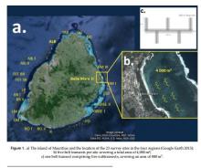
The Republic of Mauritius consists of a main island, Mauritius (20º17’ S, 57º33 E), and a group of small islands in the South West Indian Ocean namely Rodrigues, the Cargados Carajos, Agalega, Tromelin and the Chagos Archipelago. The total land area amounts to 2040 km2 whilst the marine exclusive economic zone covers an area of about 1.9 M km2 extending from 100 S to 200 S and from longitude 550 E to 750 E.
The sea cucumber industry, which is known to be particularly vulnerable to overexploitation and collapse, has been under tremendous pressure in Mauritius since the mid-2000s. Consequently, in 2010, the Ministry of Fisheries imposed a two-year ban on the collection of sea cucumbers, which was later extended for another four years (2012–2016) to avoid the collapse of the fishery.
The following country report begins with an overview of coastal livelihoods in Comoros, which provides a concise overview of the seven sector reports and the findings of the in-country and regional consultants. This overview ends with a conclusion which summarizes the collected information as it relates to the coastal zone in Comoros in general.

The Republic of Mauritius consists of the main island of Mauritius and several outlying islands namely, Rodrigues, Agalega, St. Brandon, Tromelin and Chagos Archipelago. The total land area of Mauritius is 2040 km2 the while the Exclusive Economic Zone (EEZ) is about 2 million km2. Mauritius has at different periods been a colony of the Dutch, French and British. Effective Dutch Colonisation of the island started in 1598 and ended in 1710.

The Republic of Mauritius consists of a group of islands situated in the South West Indian Ocean at latitude of 20.17°S and a longitude of 57.33°E. It comprises mainland Mauritius, Rodrigues and Saint Brandon, Agalega and several outer islands. It enjoys a subtropical climate.